Showing posts with label GPSMAP60. Show all posts

Monday, February 18, 2008

My honest opinion about my Magellan eXplorist

I got an email/survey link this morning asking my opinion of Magellan's products and this is how I replied:

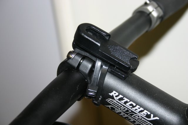
Unfortunately, I find the eXplorists very difficult to use. The instruction manual is difficult to read and you would think with all the power that the device offers it would be an outstanding little unit but it's not. It's accuracy stinks, doesn't hold track in dense cover and from what I have seen so far, the only way it has a modicum of success is to hold it horizontal with the ground plane. I am a mountain biker and the only way to do that is to mount it on the handlebars or the stem and that is a no win situation because even the mount is very ungainly.

You probably don't want to hear this either, but a few of my friends have some different versions of you Trillion series - I was tempted to get one of those but after hearing their horror stories with the bugginess of those units, I am not. My next GPS purchase will most likely be another Garmin. I have two already.

Also, I recently downloaded your free software that interfaces to the unit but found that it doesn't offer me much. I can look at tracks, when I can get the interface to work, which seems like once in a million times, and then so what. I can't edit tracks - can't do anything with it. Again, Garmin has you beat there, too.

If you would like to contact me directly, feel free to email me at eatsleepfish [ at ] gmail dot com. I would be happy to discuss your products further.
I really thought the eXplorist was going to be a good alternative to my GPSMAP60 but it performs just about the same, if not worse at times. Seems the most accuracy with the unit is achieved by keeping it horizontal, which is a tall order for a mountain biker. That would mean mounting somewhere on the stem or the bars but I have broken enough of my Garmin mounts to know even that is not a safe place for a GPS mount.

The best comparison of my eXplorist to my GPSMAP60 (my first Garmin Product) can be found here:
eXplorist posts. My MAP60 isn't all that great, either, in comparison to the Garmin Edge, of course. Not sure if anyone has anything comparable at this point. In that ride at Trumbull, the Map60 outperformed the eXplorist by holding track much better.

Here is my best comparison of the performance of the GPSMAP60 and the eXplorist:


As you can see they are pretty evenly matched. The blips are when I took the pack off and it swung one way or the other. I have seen that alot, but you can see where there is a big red line and that means the eXplorist lost track. I suppose to give these two units a really fair shake I need to run them side by side and I might give that a shot by doing the entire Larkin State Bridal Trail on my fixie. I was driving through Southbury yesterday and was able to get a good look at the northern section of the trail and it looks a little rougher compared to the rest of the trail. In fact, I might have to run all three to get the most accurate comparison.

I will have dig up the posts from last year where I have used the eXplorist. Just have to finish tagging all my old posts.

Hopefully some honest feedback will get them to improve their product lines.

Sunday, January 06, 2008

Crazy CT Weather: 45 degrees in January!

Had a great ride on the Qball at Pequonnock River Valley with Rich. Couldn't pass up the balmy weather today. Expected to be in the 50s but felt like mid 40s!

This area is perfect for single speeding that I am not sure I will bring the 'Horse back unless I want to try some of these drops that I have pictured below. Of course, once the Fixation is back to being an All Mountain HT Single Speed, probably ride that instead. Never-the-less, Rich and I haven't ridden together since Nepaug because shortly after that ride he was here and as you see down below, did this jump (pictured below) and broke his scapula. Two months later he is now back on the bike and riding, slowly, but still riding.

I am thinking it's time to get a computer to atleast track the actual miles because until I get the Edge back, these two other units are driving me nuts. They work reasonably well but not as good as the Garmin Edge. The MAP60 (green track) outperformed the eXplorist (red track) today, think because of where it was in the camel, in the media pouch with the antenna sticking out.

The eXplorist was on the shoulder strap in a pouch. Still need to test the eXplorist on the stem to see how the performance is there because I read somewhere that it has to be parallel to the ground to reach it's maximum efficiency. Just have to figure out a way to hold it there. The OEM handlebar mount is horrible and the Garmin Edge is the only unit that I have seen so far made for the stem.

The report from Huntington SP yesterday was that to have a good ride you need studded tires, something I don't have, so I opted to head south. Bunch of guys from Crankfire were headed to Westwoods but that was too far for the little time that I had to ride today. Similarly, Mianus is the only other warmer weather riding area that I would think would be devoid of snow. Mianus, while often joked about by it's namesake, again too far to drive.

Took a new trail up out of the old reservoir that linked up with the yellow trail just before the picnic tables. At this one roller/drop called the lunchbox we met up with a trio of guys from Class Cycles in Southbury that were warming up for the picnic tables. The 29er rolls things alot differently and I could feel it here. It was fun.


Didn't get any names but this guy is riding a ferrous Gary Fisher and he going big everywhere.


This guy is the mechanic at Class Cycles and he was the star of the show.


This is some guy on a 2006 Specialized Enduro (?), the one with the Brain Shock.


Looking up at the Roller (with ladder) and drop that follows.


The guy on the Ferrous Fisher cleaned both stunts nicely. Steal is real!


At the roller play ground, I slipped on a root and did the lower part of this roller my side. Here is another attempt.

Here is the jump that got Rich. If you hit it too fast it turns into a gap jump and you soar through the air...


... as Rich found out two months ago. See the scrape on the tree Rich is pointing to? That is where his shoulder hit. This is at least five feet or so off the ground and ten feet from the jump.

Again, the guy on the ferrous hucking it.

This is the third guy from their group, riding a Foes Weasel with a hydraulic rear cantilever brake.

And the man of the hour, the mechanic from Class Cycles nailed both times!


Rounding a corner before the last stream crossing I hid a muddy patch and went down in the slop.


Except from the occasional splatter from mud I was reasonably clean before this latest mishap.

A good day of riding with friends and new friends is better than just about anything.

Saturday, December 29, 2007

Saddle up little doggies!

I am back on the 'Horse! Picked her up from EMS two weeks ago but due to the weather and the holidays just didn't have a chance to see how she runs after the almost month long visit to EMS. If they tuned it up, I sure can't tell if they did anything except address the issues that I brought it in for, which by the way appear to be resolved.

I went out to Collis P Huntington State Park today and started at the Dodgingtown lot. Conditions were absolutely crappy. If you weren't riding on crusty, slushy, packed snow/ice then it was wet everywhere and I should have thought to have brought my mud flaps! Doh!

I initially planned on doing just a circumference ride on the blue trail but had to give the singletrack that starts by the glacial erratic a shot. Half way through I thought my rear tire was a little low on air so I stopped to put some more in but the release valve snapped off and the tire immediately went flat. Good thing I had a spare tube on me.

This was a first for me because I don't think I have ever had to change a flat while on the trail. I initially snapped a tire lever trying to get the bead off the rim and I thought I was screwed but I found my other tire level and was able to get the tire open and changed tubes. I think I must have lost 30 to 40 minutes on that operation and had to cut my ride shorter.

Still the conditions were awful. Hopefully Monday will be better as I go for my last ride of 2007.


I did get to try out some new gear, though. It was in the 40s so I had a short sleeve jersey on, turtle neck, and my official Bikerag "Don't shoot me bro" blaze orange riding jersey.


Also tried out my new Camel, too. The Mule, which I thought, for some reason, would have more little compartments than my first hydration pack made by Sierra Designs. It is, however, more roomier with a main compartment that is not shared with the water bladder as in the SD one. On top is a media pouch which my Magellan fits nicely in. Have to try the GPSMAP60 and see if I get better reception here because on the strap, where I rode with it today, I got a horrible track. Good thing I had the Magellan for back up!

I really like it's fit and how forms to the body. I could barely tell it was even there at times. The 100 ml bladder will be nice in the summer. The SD has a 70 ml bladder.

Sunday, April 01, 2007

Middlebury Greenway

In Middlebury, Connecticut there is an old Trolley bed that at one time linked Waterbury to the Quasi Amusement Park or back in the day was called a Trolley Park. The Trolley Bed continues onto Woodbury and parts of it can still be seen today.

So, Katie, Elliot, Larry (Katie and Elliot's Grandpa) and I decided to ride the Trolley Path and do some Geocaching at the same time.

Below, Katie is looking for the first Cache.


Here it is, a magnetic micro cache.


Qball rigged for Geocaching

Saturday, September 23, 2006

Long Stem GPS Mount

If you have a gps with one of those belt clips similar to the cell phone ones, you can do this mounting in 15 minutes. It will be helpful to grind down the sides of the belt clip so that they fit between ridges on the stem for the bolts. Then use one zip tie to around the the fat tube portion of the stem. Another zip tie goes over the tube, then over the bars and then back around again. This ensures that it won't shift in place. You could add another ziptie going the opposite direction just to be sure.

Then find yourself a piece of foam rubber for cushion and a small bungee cord to hold everything in place and voila!

Posted by Picasa

Thursday, July 27, 2006

GPS Accuraccy: AM vs PM

I rode twice this week in the Upper Paugussett, once on Tuesday afternoon and again on Thursday morning. Rode the same course both times and the the morning ride, I dropped signal on Sanford Road like every other time in the past when riding in the mornings.

I posted the question on Groundspeak forums on whether there is any issue with the Sat Signals between morning and afternoons and one of the responses that I said the following:

Satellite configuration is the most likely cause. The satellites move in orbits of almost 12 hours. Where they are has a direct impact on signal strength.
So it appears there could be some influence in positioning.

Well, Thursday was my last ride for awhile, because Thursday afternoon I had a little outpatient surgery that will keep me out of the saddle for a couple of weeks. Needed to have something fixed to prevent any more future college tuition payments. I figure three kids are enough.

The procedure wasn't too bad. A little sharp here and there even with the local. Post surgery recovery includes alot of icing, keeping off my feet for a couple of days and percosets. Still, it feels like I got kicked in the you know where, twice, when the percoset wears off.

Hope that wasn't too information for you.

Thursday, June 15, 2006

CT NEMBA and Mountain Bike Action

We had a member's meeting and ride on June 6th at Wadsworth SP. Besides the BOD, there were two members. Wadsworth is a nice little place if you are a beginner. Some tight single track and many carriarge roads. Little falls and Big falls are worth looking at. I posted some pics at CTNEMBA.org. After the ride we had Pizza, conducted our board meeting, and then I officially became a trail ambassador. Got a couple of Jerseys, a folding saw, and a Topeak multi-tool. Now when I ride, I can log my hours and report on any problems on the trails that I might come across.

The following Monday, I showed a photographer for Mountain Biking Action around Huntington SP. Spent the weekend trying to coordinate some other CT NEMBA members to show up and was about to get Ed Perten and a riding buddy of his to come out. We ended doing a mile of Rock and Role and the photographer probably shot 100 or more pics at about 5 different spots. You had to ride through the "kill zone" (where the camera would take the picture and the flashes would go off) 10 or 15 times, each of us and then in groups. "Posing" for the camera while riding is tough work.

On Thursday of that week, I led my first CT NEMBA RAW (Ride After Work) ride at Mianus. A friend from work, Paul F, was there and there were two more NEMBA members. One guy that I only know as Marc F., who I don't think is an active member or I just couldn't find him in the membership database, and then a guy by the name of Dave M., who I happen to know from www.bikerag.com. It was good ride, we basically recreated the ride that Paul and I did with Alex F last month. Dave had to bail half way through due to back problems. It was great ride.

I rode with my GPS mounted to my top tube and surprisingly, that is a very accurate position because we were in some dense tree cover and I never lost signal. I took a extra cell phone belt clip and zip tied it to the top tube and handlebars and I can see the screen for the most part.

Thursday, February 16, 2006

Lost signal!

Rode with the GPS today in my cell phone holder which is on the shoulder straps of my camel and I think at one point is slipped down to the sternum strap and I lost signal. Hence, no map today but it doesn't matter because I only had time for a quickie. Riding in the snow was increadibly tough because this snow was very wet and about 5 inches deep. Great traction and also great for snowballs, but horrible to peddle in. That was a nice workout for lunch, though, that leftover pizza I had fueled me nicely.

Later in the day, I drove up to Middletown to attend my monthly CT New England Mountain Biking club meeting. If you recall, at the January meeting I volunteered to be the Membership coordinator. I wrote a nifty little database using MS Access to track the memberships and pull statistics monthly.

Tonight, I was officially voted in as a board of director. It looks like we will be going forward with my membership postcard idea. That is a 4x6 laminated postcard with CT NEMBA contact information that is to be handed out to people seen mountain biking who are most likely non-members and put on car windshields at popular mountain biking destinations. Hopefully this will attract more people to visit our CT NEMBA website and hopefully join the club and get involved.

The picture is of Deeman from Crankfire.com riding a log at Huntington SP. The picture was taken by Mike Marques, a professional photographer and avid mountain biker. I keep asking him when is he going to put out a coffee table book of all of his pictures because they are awesome!

Saturday, September 10, 2005

Pequonnock River Valey - Trumbull, CT


Finally rode Trumbull's Pequonnock River Valley and OMG what a place. There was quite a turn out from the CF crew, too. Quite a ride. Should have been wearing by elbow pads because I fell twice on my left elbow and have a nice couple of scrapes to show for it. Also bashed my peddle again and this time its cracked all the way thru. Lastly, I broke my GPS mount. Where its located is just not good for Freeride. Rode the rest of the way with it in my hydration pack and it wasn't too bad. Tracked pretty well. Posted by Picasa

Thursday, June 02, 2005

Brought home a Christmas Tree!


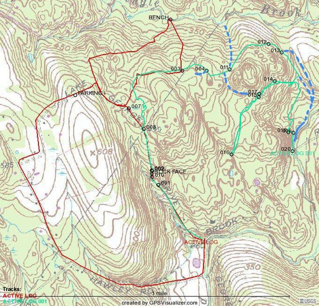
So, here are the results from this morning's ride. The green track is from today's ride, the red is my initial Burr Farm OS ride, the dashed blue lines trails that may or may not exist (I will explain, later).

As you can see I didn't quite find the loop that I was looking for by the fact that I had to turn around (appoint 16). At WP 15 there appeared to be a trail that may head down to Pond Brook but I wasn't sure. There might also be a trail that hooks back to the main trail, that is why I put the blue dashed line because I don't really remember. What I do remember about this location was trying to up a small stream bank, hitting a rock, and going Endo (over the handle bars). That was fun.

The trail that leaves the red trail at WP 3 is a nice ride, nothing too steep or technical, in fact you can really get going through there. At WP, 4 there is a trail that intersects that was marked with orange engineer tape. At WP 11, there is a trail that branches to the north and heads down hill. Might have to see where that goes on the next ride. At WP 12, there is a nice stand of pines. WP 13 there was trail branching off from here that headed down the hill and looked to go towards the fields (shown on the topo from the previous post). I think this might lead to the trail along Pond Brook.

After turning back from WP 16 I probably should of headed down the hill from WP 15. It really didn't look like a trail but it would have mostlikely brought me to the one that I found after back tracking almost half way back to WP 13. As you can see, I had to bushwhack until I found a trail that took me to Pond Brook.

The next time I ride this, I am going to try it from the trail along Pond Brook and see where it leads. Hopefully it will connect at WP 13 which combined with the rest of the trails will be an excellent additional to my Burr Farm OS Ride Map. These trails are green trails but there are quite a few nearby rollers to venture out on. Combined with a run down to the bench on Dingle Brook and then back up towards the Burr Farm OS Parking lot, will make an excellent workout ride.

More to come...

Tuesday, May 31, 2005

Upper Paugaussett Trail Map


Spent an hour and a half getting throughly confused yesterday in Paugaussett SF. Rode the blue trail from the parking lot (olive green) at the entrance that intersects with an old Jeep trail (Blue & Red) on the eastern boundary. Interesting little ride that consists of two hike-a-bikes (the art of dismounting one's ride and pushing, carrying, schlepping, up a hill that is too steep to climb peddling, or if one is just too tired to do so), one was up a ledge along a little cliff. I felt like Lassie and little Timmie was trying to coax me up to safety.

Between the hike-a-bikes is a beautiful right of way (ROW) from days gone past. Both sides are edged with 4 foot stone walls. Unfortunately, there are too many trees down to make it passable. This ROW is the one that runs from Albert's Hill/Al's Trail intersection up past the house at the start of the SF and into it the woods (SF) proper. It's probably how the farmer(s) moved livestock and wagons into the area for farming. Acording to the maps I have seen, at one point it just stops which makes me think that it was the route to fields.

So, heading down hill I hit the old jeep/logging trail which starts on Sandford Road, so I guess this means it turns into the blue trail. There is a branch off which is marked with blue/pink engineer tape (olive & red), that I rode a couple of weeks ago. This trails appears to be a cut-off from the blue trail that gets around some really nasty climbing (yes, more hike-a-bike). I wonder if this might have been put in by a fellow rider. When I intersected with blue trail again, I went south to see where this goes and found that it climbs to the top of one of the highest points in the SF and then drops sickenly down (hence the by-pass maybe). Picked up the blue/pink again and found that it bypasses this steep climb another way, too. So, is the purpose of the blue/pink just to get around this steep part or what?

So I followed the other blue/pink cut-off back up the hill, picked up the blue, rode past where I the other cut-off intersects with the blue to where the blue turns due west towards the exit of the forest. At that point, there is a trail marked with pink tape that cuts over to the main Jeep trail. There were more blue markers headed into the woods in the direction of the Pond Book Boat ramp and Al's trail but after 100 yards I lost the trail and headed back. I did find a nice camping area with a fire ring. Getting back to the Jeep Trail (green) for the final down hill ride and the ride was done.

The upper part of the blue trail shown on the map above, starting where it breaks off from the olive trail was indeed a trail that lead straight into someone's back yard. I recorded this track on my GPS the first time I rode the eastern side of the state forest. Rather than back track to find the trail I should have been on, I bushwhacked until I found the blue blazed trail which led me down to the jeep trail and out of the forest. Bushwhack riding is challenging.

Also, I have captured part of Al's Trail (tourquoise). Three quarters of the way, where it does a 90 degree turn and heads due south is a white blazed trail that hooks up with another blue trail (engineer tape) that leads to the Jeep Trail.

More trails to come.

Saturday, May 28, 2005

Middlesex Community College


Rode from Middlesex Community College with the Crankfire Crew today and let me tell you, these guys are some sick riders!

Above is the track of the ride. The waypoints are all the trail intersections with other trails. If you would like to see a more comprehensive map of this location check out this link: Middlesex Community College

I must admit, by the time I marked my first waypoint (001) I was ready for some dual track fireroad. Single Track riding here is brutal. Upon entering the forest you are riding/threading your way through a tangle of Mountain Laurels, open face rock, over many logs and bridges, and through various streams.

While riding in this terrain was a new experience for me I really appreciated the Crew for letting me catch up to them. I learned something very important about mtb in rough terrain: Momentum is key for negotiating difficult terrain - if you are going to slow, you are going down or you are going to walk. I also learned how to log jump and had some successes and quite few stop shorts, which came close bashing my nards on the handlebars.

I also learned that rocks are hard because one of the crew did a face plant on one. Ouch! Fortunately, Amanda, a.k.a. Rocky, didn't get hurt seriously. Just a bloody nose and cut on her cheek.

I am going to have to get some better gear, first on the list is shorts. The sweatshorts I was wearing this morning either kept getting caught up on the bike seat or wedged up my fourth point of contact.

It's cool how you can find a website dedicated to mtb in your local area, hook up with people you have never met and have great time. The webiste I am talking about is called Crankfire, its really a forum for MTB only the moderator has a passion for GPS and when you marry to the two together, you make maps, like the one above.

By the time I arrived back at the parking lot, both legs were bleeding from various cuts and scrapes receive along the way and I was soaked in sweat. Granted, I was wearing a long sleeve T and a short sleeve T underneath. I drained my Camelback and not once took a leak. I think might have dropped a few pounds today!Posted by Hello

Friday, May 27, 2005


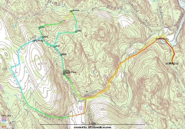
Here is my map of Burr Farm Open Space Ride. I have the start point at Bramble Trail (though not really shown on the map). I used GPS Visualizer to make this map. This is a good ride that can be done in about an hour and provides a great mix of terrain. The trails are mostly single track riding, except for the rights of way (ROW). There is alot of climbing, crossing streams and riding through some really interest property.
You can park at the Burr Farm Open Space Kiosk located at the top of Dinglebrook Road but from Bramble Trail its almost a seven mile ride. Going up Hawley Road is challenging because its an old right of way (ROW). The homeward leg, going down Lake George Rd, another ROW that is impassible to vehicle traffic.
I plan more updates to this map because there are numerous trails coming off of the Open Space Trail (blue blazed) that have yet to be explored. I hope to find a trail that connects the Newtown Forest Association property north of Pond Brook to this area which would make for some really good riding.
Posted by Hello

Mountain Biking at 40

My father told me life begins at 40 and here I am, 40 years old, a house, a wonderful wife and two beautiful kids, and another on the way. I enjoy what I do for work and I am involved with my town's government by volunteering to perserve open space.

I have seen some of my contemporaries, when they hit 40, go through the proverbial mid-life crisis. They go out and get a fancy sports car to make them feel young again. I don't have the time, nor the cash, for that kind of extravangance. I have two young kids that keep me young.

I still need exercise though and after fifteen years of military service, which comprised of Active Duty, Connecticut Army National Guard, and the United States Army Reserve, Physical Training or PT as it's called, has taken its toll on my knees. Thus, the mountain bike.

Now, take Mountain Biking or "MTB", add a GPS, and what do you have? A new hobby that's good for you. With GPS, I track where I ride in the woods, then come home, download the data to my computer, and voila! I have a topo map of where I have been and where I might go again.

I have found two websites that cater to this, MTB and GPS, in the State of Connecticut. You will find their links on my links payne. The Crankfire Website is hard core riding with a GPS. Bikerag has maps that the webmaster has created and a few others have contributed, as well as myself. Check out my Burr Farm Map on Bikerag. Its also on Crankfire, too.

So, the purpose of my blog is to bring you anything and everything to do with MTB'ing in my life. I will post maps and ride reviews of my own jaunts around the state. I also thought I would separate my MTB endeavors from my other blog, Meine Aufnahmen (My Pictures). There you find pictures of my family and artistic pictures I attempt to take with my digital SLR.

Let's see what happens.