Showing posts with label GPS Visualizer. Show all posts

Sunday, January 11, 2009

How to make a Ride Map

I was reading on Charlie Rides a Bike about is little ice-less adventure down at Rocky Neck State Park and I know there are a lot of riders out there that have GPSs and ride with them but I don't see many post ride maps on blogs. Therefore I thought I would throw together a little tutorial. Also, this is good for riders who want to make a map of an area that they are new to, assuming of course you can read a map.

There are quite a few programs that you can use, and some with some insane detail, especially using satellite imagery, however for this tutorial I am going to show you an online web utility called GPS Visualizer that takes a lot of the guess work out of the other applications. Some apps don't let you export the images to a graphic file in which you can print from but GPS Visualizer does and that is one of the reasons I like it.

  1. Download GPS data. The best format to use and the one that is most portable is a file with the GPX extension. For more info on this format look at this wiki on GPX. If you use a Garmin Unit, like one of the Edge series, the format is proprietary, but you can use other applications EasyGPX or Topofusion to download the data right to the gpx format. You can also convert what you already have stored on your machine using a website called GPSies. Just click on the Convert Tab and look for the format you want to convert from and to. GPSies will even import directly from your Garmin unit.
  2. Edit your data. If you are going to publish your maps to a blog or a website, you might not want to include extraneous routing information like to where you live or if you had to park a ways off and shamelessly put those knobbies on the hardball. TopoFusion let's you edit tracks but I have never been successful using it. I prefer using Garmin's MapSource. MapSource also will pull from your Edge. One thing to remember about using MapSource is that it saves files in it's proprietary format (*.gdb v3) so if you want a GPX file (which it will read) you have to do a Save As.
  3. Preparing your data. I find using GPS Visualizer the easiest to use, or maybe it's just that I have been using it so long that I am just accustomed to using it. One caution, however, if your track is really, really big (covers a huge area) then you may want to consider using something else that will give you the scale you need and the level of detail you want. If I needed to do something along those lines then I would find a site that uses Google Maps with the terrain option. The only drawback is I haven't found anything along these lines that lets you use multiple files so you would have to merge all your GPS Data. Best tool for that would be TopoFusion's make network feature.
  4. Uploading your data. From the main screen, select the type of map you want to work with and it will open up to a features page where you can select specific settings for you map. I tend to go right for JPEG option of the JPEG/PNG/SVG maps selection everytime.

    The Profiles option is another one that I have started to use more. If you are in the US, the one feature you want to ensure is that you select the U.S. in the units dropdown.


    This is why I like GPS Visualizer so much because you can upload multiple files. If you had a collection of track files from a particular area, you can upload all of them here and make a network map.
  5. Draw the map. In either option, once you have your settings configured and the files selected, hit the draw the map button. Here is Charlie's ride at Rocky Neck State Park done with GPS Visualizer. He uploaded his track file to Motionbased.com where I was able to export out to a GPX file. His track included a road ride from his parents house that I didn't want to include in this map, so I took it out using MapSource. You can tell the thicker lines are where he looped the trail. Here is what his profile looks like:

If you want to try making a map sometime, you can scour the interwebs for GPX data on a particular area, download it, and make a map of it for your next adventure. One word of note, GPS Visualizer is only for US and Canada. If you are not in North America then you are probably going to have to find some sort of Google Supported site and in order to create a static map, you will need to take a print screen of it and save it in a image format. TopoFusion, has this feature built in but if you are using the freeware version the map download is a little wonky and has DEMO on each of the tiles.

As far as the other sites go, especially those that use Google Maps, they won't let you make a map of a networked file using TopoFusion. I tried this on MTBGuru and Motionbased. If there is a site out there that you have seen that lets you do multiple tracks on a Google type map, let me know!

Thursday, April 13, 2006

Mianus River Park

Mianus River Park, brings back memories. Long before I became a mountain biker, I was on the Board of Directors for the Mianus Chapter of Trout Unlimited and of course our namesake meant we were quite involved with the Mianus River and especially this park, and one of the things back then (mid 90's) we were vehemently opposed to in the park was of course, Mountain Biking. However, all that animosity has been put by the wayside thanks to Paula Burton and CT NEMBA. Apparently NEMBA has done quite a bit of Trail Maintenance there starting in 2002 and has gotten TU involved, too. Kind of ironic.

Well, the day started out with one big worry after yesterday's little problem with my rear derailuer but I was able to get it fixed, between meetings today, by Brian at Hickory and Tweed in Armonk Village. Ironically, Brian said that he was probably going to be riding Mianus and sure enough we ran into him. Brian rode with us for most the time out and like Alex, Brian can hammer.

Mianus is an intense place to ride with a ton of variety in the trails. You can ride flats (river valley, duh) or you climb hills. On the sides of the valley the trails tend to be gnarly rooty and really techy and there hucking opportunities all over the place. Nice little ones right in the middle of trail to 3/4/5+ rocks surrounding the trails. Trails are maintained well, too. Bunch of fishermen that spoke to in the parking lot complained that the trails were really getting worn down but I didn't see that. From their purview, I think they were speaking of the trails that get them to the river. Trails that lead away from the river are nicely maintained and well marked.

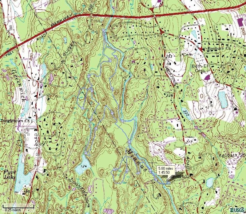
So, of course I uploaded my track file into SportTracks and found in the latest version you can export the map so here it is below.

The track is pretty good as it lies on the map. Also what I like is it shows you the direction of travel and a little flag at the start of the ride, the distance and time of the ride. This is a great program. Of course what would make it even better is if it showed elevations in colors like GPSVisualizer does. Another thing that I don't like about the export map is that the track is hard to see on the map. It looks better in the software but not by much. What would be helpful is if you had the ability to change the color of the track and you could vary the map's opacity so that the track stood out. Might have to suggest this improvement to SportTracks along with asking why it won't read my GPS.

And here is the same track shown in GPS visualizer. Obviously, each program has its strengths and weaknesses. GPS Visualizer lets you also display multiple tracks, as you probably have seen in my earlier posts, and waypoints. So from a mapping perspective, GPS Visualizer is much more handier.

Let me know what you think is more helpful, GPS Visualizer vs SportTracks.

[Post Ridem Report]This is the first time I have ridden two days back to back and my legs are screamin'!

Friday, May 27, 2005


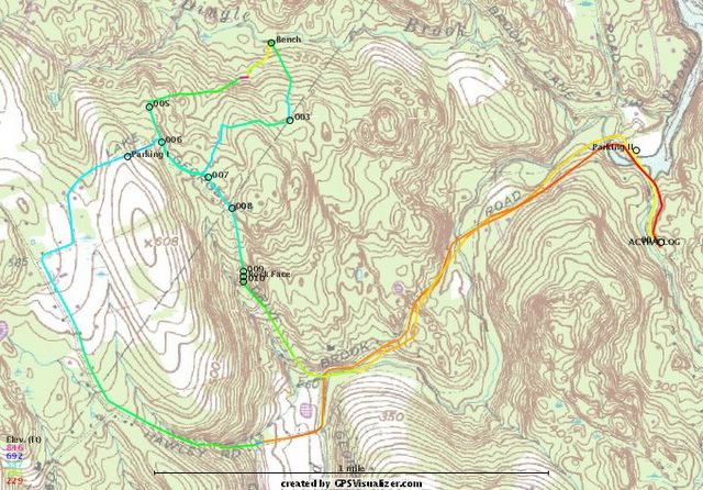
Here is my map of Burr Farm Open Space Ride. I have the start point at Bramble Trail (though not really shown on the map). I used GPS Visualizer to make this map. This is a good ride that can be done in about an hour and provides a great mix of terrain. The trails are mostly single track riding, except for the rights of way (ROW). There is alot of climbing, crossing streams and riding through some really interest property.
You can park at the Burr Farm Open Space Kiosk located at the top of Dinglebrook Road but from Bramble Trail its almost a seven mile ride. Going up Hawley Road is challenging because its an old right of way (ROW). The homeward leg, going down Lake George Rd, another ROW that is impassible to vehicle traffic.
I plan more updates to this map because there are numerous trails coming off of the Open Space Trail (blue blazed) that have yet to be explored. I hope to find a trail that connects the Newtown Forest Association property north of Pond Brook to this area which would make for some really good riding.
Posted by Hello