Friday, April 28, 2006

Happy Bikeversary!

So, here it is. One year later.
Some stats:
1. 316 miles ridden to date and this month I have topped out the most miles I have ridden in a single month, which is 61 miles. Of course, if you subtract the 15 miles from the Cockaponset ride it still works out to be a net increase in riding by 118%!
2. Dropped 15 pounds and consitently keeping my weight around the 200 to 205 mark. Pants fit much better and I gained another hole on the belt!
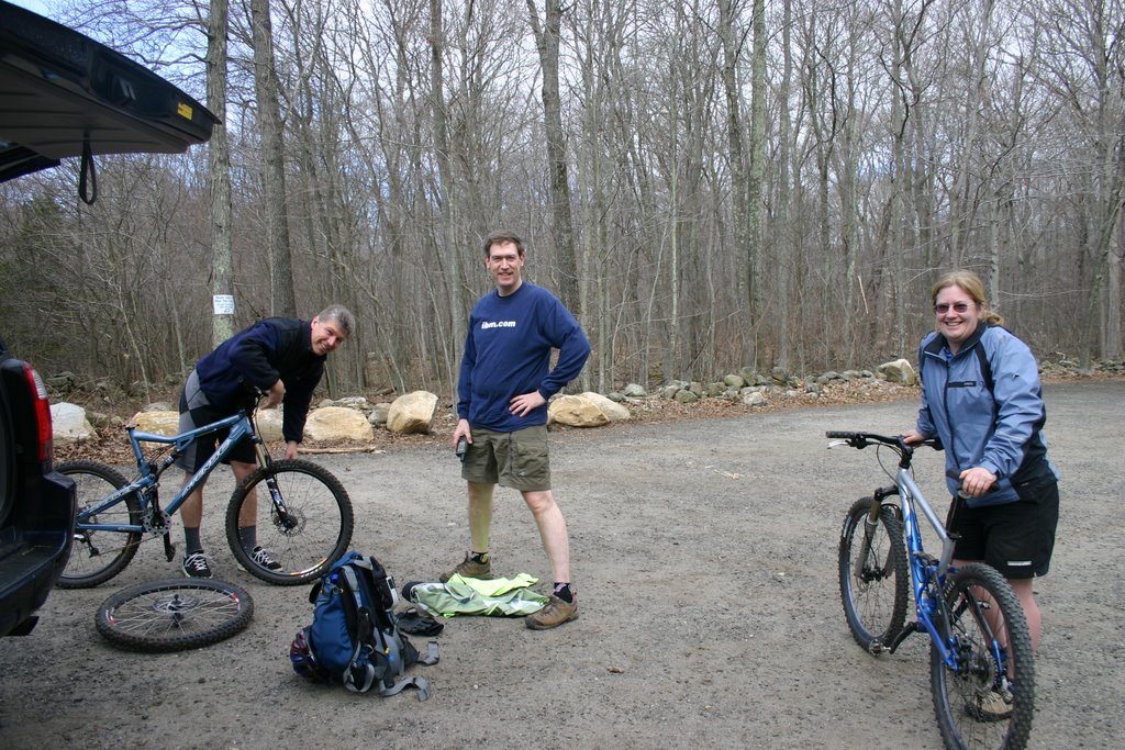
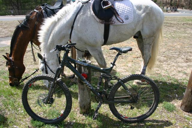
3. Two and a half bikes. The Trek 3700 was fun and still has a purpose in life - trailer biking and riding with the kids. Once Katie can ride on her own I am getting a rear seat for Elliot. Not sure if I am going to get the kid trailer. I can just imagine Elliot squeezing Brodie's hand too hard, Brodie crying, and me not going any where. The half bike is Katie's trailer bike. And then there is the brute, weighing in at around 37 pounds, the Giant AC. This bike has performed beyond my expectations.
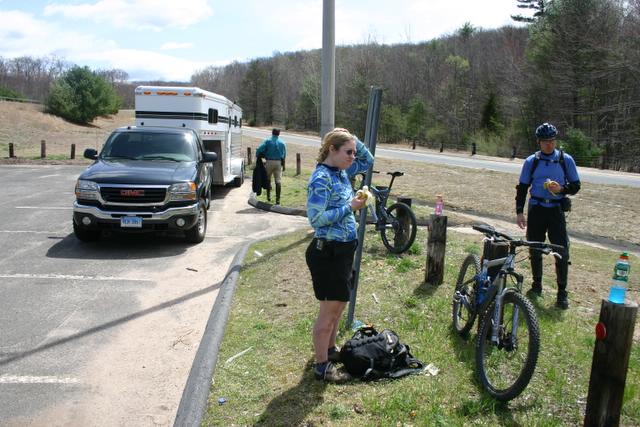
4. Established a presence in the Connecticut Mountain Biking community, with some spillage into Westchester County. Joined NEMBA and am now on the Board of Directors.

So where do we go from here? More miles, more riding, more Cross Stuntry, within reason of course - don't need anymore Boomer-itis statistics for the medical community, and definitely want to start racing. I think I want to get the 29'er for that. That will be my venture into realm of clipless peddles and who knows, maybe I will convert the AC to clipless as time goes on.

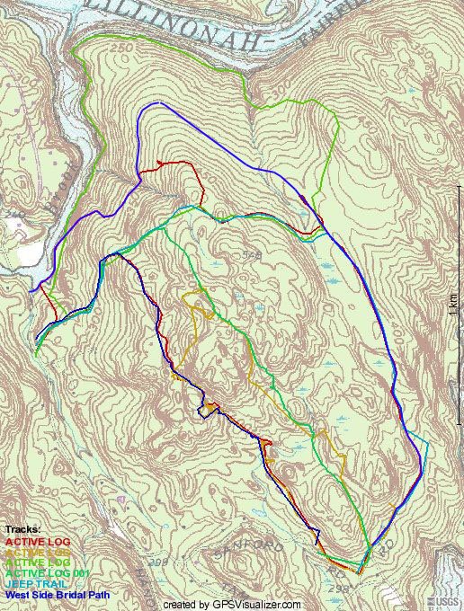
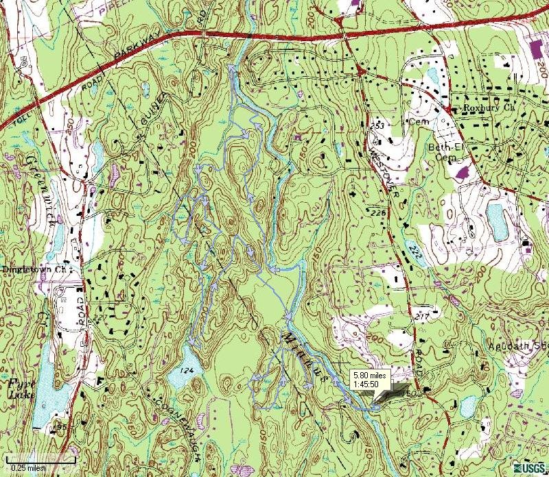
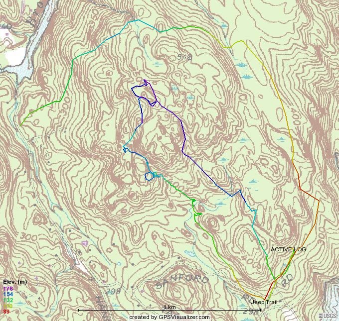
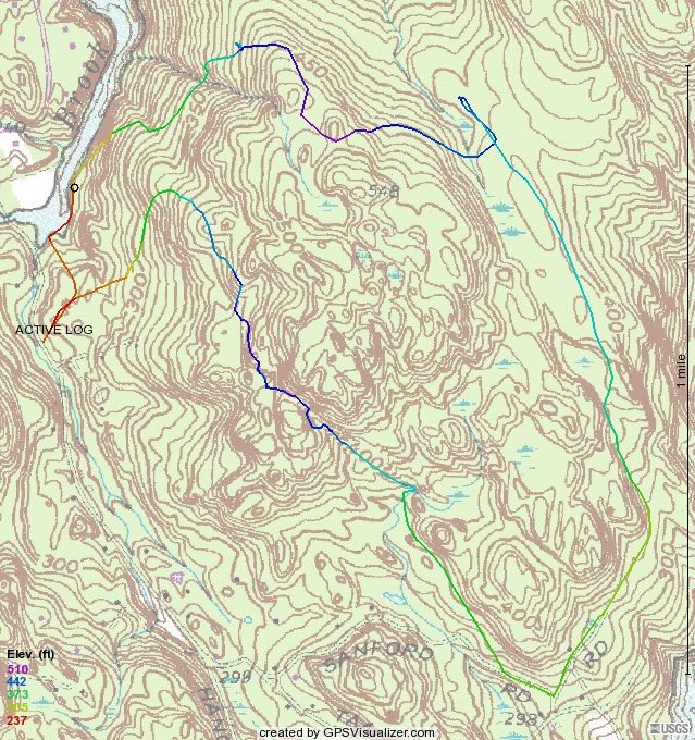
Recap of today's ride in the Upper Paugussett State forest (map above). I decided to follow a notion that the current layout for the Polly Brody Forest Road wouldn't make any sense a hundred or so years ago so I decided to follow the connector on the White trail and found that there is a road, approximately the same width that continues on into the forest heading towards the lake. I followed the trail about 100 yards in to where there were a lot of trees down and it seems to continue on.

Below is my approximation (blue) of where this road would have continued if my theory is correct because where I pick it up on the dropzone leg (red track line), it appears to head into the forest, in the approximate same direction. My guess is that it follows the contours and climbs as little as possible, curves around the hill to meet up with the section near the white trail.

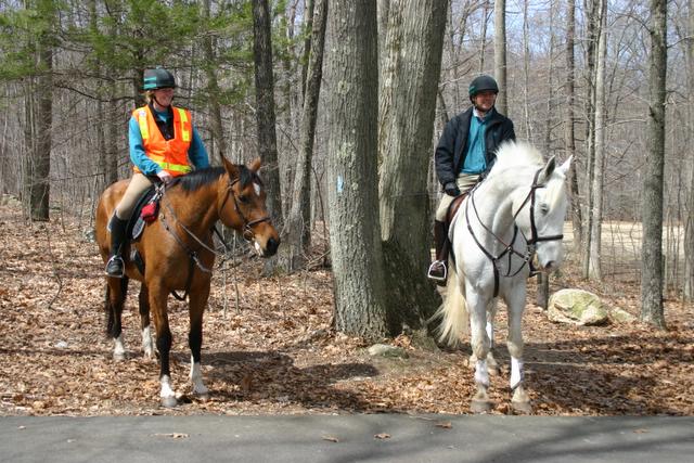
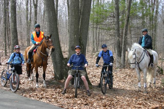
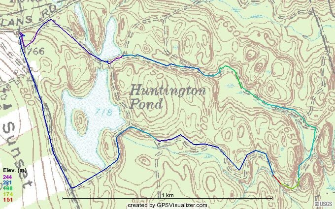
Also re-rode what I called the Equestrian Trail that I rode last fall with Lame NYer and found all sorts of Newtown Open space markers, so the "Yellow" trail which is NBLA's first attempt at a trail through this part of the forest definitely crossed into the Town's openspace property and that is obviously a no-go. Even with the proposed changes that we walked (Cindy and Paula) a couple of weeks ago, the climbing is such that the trail would not lend itself to be a good mountain biking trail. So, it looks like the Multi-use trail that we were planning for the forest might have to take alternative route, especially if we can't get CFPA let us traverse their hallowed ground.

Monday, April 24, 2006

Calm before the storm

Weatherman said rain all weekend and heavy at times but maybe I heard the forecast wrong because it was certainly wet on Saturday but not that bad. So in the afternoon I went out on what should have been a short jaunt but ended up taking an hour and thirty. Got sidetracked on the Up and Over. I think I got it figured out - logs on the high side make a ramp up and rocks on the low side for the ramp down. Next ride, I am going to give it a show when I have some armor on.

Rather than head down to the Drop Zone, I found where "the road" turns almost due north and heads downhill and then turns west again. Pretty overgrown but doable. After it turns west it becomes a nice trail/road that is rideable both up and down. Still needs a little more work - don't want a branch in the eye.

One thing I noticed is that where it hits Al's trail, it actually crosses and heads down to the river. I might try to continue through there next time only because I really don't like encountering walkers and hikers on Al's Trail. I think I use most of it still it hits Pond Brook where I think it went to a ford and then cut back up, take a little of Al's trail and then cut out using the Equestrian right of way back up to the Polly Brody.

Here is the aerial. Kind of looks better. What would be nice is if you could get an aerial/topo overlay. It did rain like the Dickens on Sunday though.

Wednesday, April 19, 2006

14 miler in the Cockaponset SF

CTNEMBA and the Bridal Path Coalition teamed up today and rode through many of the Cockaponset State Forest Parcels. We met at Seven Eighths Farm
and from here we staged a horse trailer at Exit 8 off of Route 9PX file and you will get a much more detailed view of this Epic Ride.

The ride began at the Webber Woods parcel of the Cockaponset SF, which unfortunately doesn't have an online map but it is a quintessential park that would be great for beginning mountain bikers. I found this description of the parcel on a Mindspeak.org:
Cockaponset State Forest is the second largest state and my vehicle off of Clark Road in Higganum. While the map on the left is a pretty good overview of the ride which I made using GPS Visualizer, check out www.crankfire.com where I uploaded the GPX file.

The forest It is named after an Indian chief who is buried in the Ponset section of Haddam. The DEP acquired the Webe
r parcel of 354 acres for $780,000 in 1998. Favorite activities include hiking, horseback riding, and mountain biking.


On the first leg of this Epic Ride, Paula, Alex and I started at Weber
Woods in Killingworth, CT. Here we are, pictured left. The weather started out funny. It was breezy and partly sunny and it was hard to tell what to start the ride with on. I settled for a t-shirt (which I took off after about 15 minutes) and long sleeve t-shirt. Weber Woods is primarily composed of rode dual track trails that are frequented by equestrians and mountain bikers. In fact, it seems that an organization called Sprock Kids, which is affiliated with NEMBA rides here and periodically does Trail Maintenance with BPC. There were some nice stream crossings and some not so nice because they appeared to be more like intermittentant streams and still muddy from the winter thaw. We met up with the rest of our party, two horseback riders from BPC and proceeded to follow them on what appeared to be seldom ridden trail that took us to State Route 80.

After crossing Route 80, we took another trail/old woodsman road that led eventually to some nice narrow dual track. This trail took us past the Chester Airport, although you couldn't see it, there were quite a few planes either landing or taking off and eventually we came out on Butter Jones Road in Chester. Followed that to Sypher Road which led us to State Route 148. We took a little break at the southern entrance to the Pattaconk Lake portion of the Cockaponset State Forest where I shared my stash of carrots with the horses.

The ride on Filey Road (decaying asphalt) includes a quite a bit of climbing as well as descending but there isn't much challenge because its just a road. Off to the left and right there were numerous trail heads for other trails, including the Cockaponset Trail, which was blazed, I think with a baby or Infantry Blue and a red dot in the middle. Paula mentioned that there was another trail through here called the Pattaconk Trail but I didn't see any special blazes. Hopefully, sometime in the future, this Epic trail will only have to use the hardball just to get into the state forest and then branch off into the woods and pick up one of the non-regulated trails.

We descended upon the Pattaconk lake parking area where we were met by Patty of BPC with snacks and water.


There was a demonstration on jumping rocks both by mountain bikes and horses. I think the horses stole the show. Kristen is jumping the rock with her horse, whose name is Simba.


And here is Brad on his Simba. Simba seems to be rage in horse naming.


And after quite a few attempts, maybe it was the size of the rock that proved daunting to Alex, he did finally make a good show of how to do it properly on a mountain bike.


After a few more snacks we took a group picture,


and then got back on the trail. From here more dual track that climbed the ridge that overlooks the Pattaconk Lake and then pretty much planed out for a few miles of easy riding. At one point, we came out onto a dirt r
oad, on the map is called Old Country Road, where we turned due west and the horses took off galloping. After I finished marking the waypoint on GPS for the turn and climbed the hill, the horses were no where to be seen. They are fast! Picked up another trail and actually lost satellite signal for about 20 yards or so.

We followed this trail to Jericho Road, another dirt road in the State Forest, which by this time we were now in the northern section of the forest, as seen as on the DEP's map. It was pretty much down hill from there and the bikes took off first but the horses, not wanting to be left out of all the fun came galloping after us. At one point when I was bombing this one hill I could hear the thunder of hooves gaining on me. I moved as far over on the road as I could and then Brad on Simba (the big white horse from the previous pictures) came barrelling past like a freight train.

Eventually, we came to the turn off onto the gold trail that would take us down to Beaver Meadow Road and on in to the commuter lot at Exit 8 from State Route 9. There we had some more snacks, Brad and Kristen loaded their horses into the trailer, we took a few more pictures and then Alex, Paula and I pushed on to the last leg of the trip. Here is my AC next to the horses grazing on some fine, State of Connecticut Commuter Parking Lot Grass! What a tasty treat after a long ride! I was amazed at how light Alex's Intense VP 5.5 was. It was a feather in my hands. Paula's new Gary Fisher Cake was even lighter, although it was a small frame. Compared to my almost 40 pounds Giant AC. Patty met us there, took a few group shots and I took this beautiful self portait with helmet head. Of course was funny is that after taking that picture, I realized that I had been riding with my shirt on backwards, DOH!

Mounting back up, we road more hard ball to get to the last leg of the trail, which was more dual track, that gave way to an intense double layered hike-a-bike on a trail that was pretty eaten up by Enduro and ATV riding. Trail eventually spit us out onto a cul-de-sac. Another 100 yards of hard ball to next trail head which was the really chewed up by ATVs, super techy, and worst type of trail to be on your last leg of endurance. Finally, we arrived at my car. Of course, what would have been really nice is to have cracked open an ice cold MGD when we got there but I left the cooler by the fridge this morning, DOH! So, we loaded up the bikes and headed bact to 7/8's to recap the ride and have a little a lunch.

Total Odometer on the GPS: 14.9 Miles!

Thursday, April 13, 2006

Mianus River Park

Mianus River Park, brings back memories. Long before I became a mountain biker, I was on the Board of Directors for the Mianus Chapter of Trout Unlimited and of course our namesake meant we were quite involved with the Mianus River and especially this park, and one of the things back then (mid 90's) we were vehemently opposed to in the park was of course, Mountain Biking. However, all that animosity has been put by the wayside thanks to Paula Burton and CT NEMBA. Apparently NEMBA has done quite a bit of Trail Maintenance there starting in 2002 and has gotten TU involved, too. Kind of ironic.

Well, the day started out with one big worry after yesterday's little problem with my rear derailuer but I was able to get it fixed, between meetings today, by Brian at Hickory and Tweed in Armonk Village. Ironically, Brian said that he was probably going to be riding Mianus and sure enough we ran into him. Brian rode with us for most the time out and like Alex, Brian can hammer.

Mianus is an intense place to ride with a ton of variety in the trails. You can ride flats (river valley, duh) or you climb hills. On the sides of the valley the trails tend to be gnarly rooty and really techy and there hucking opportunities all over the place. Nice little ones right in the middle of trail to 3/4/5+ rocks surrounding the trails. Trails are maintained well, too. Bunch of fishermen that spoke to in the parking lot complained that the trails were really getting worn down but I didn't see that. From their purview, I think they were speaking of the trails that get them to the river. Trails that lead away from the river are nicely maintained and well marked.

So, of course I uploaded my track file into SportTracks and found in the latest version you can export the map so here it is below.

The track is pretty good as it lies on the map. Also what I like is it shows you the direction of travel and a little flag at the start of the ride, the distance and time of the ride. This is a great program. Of course what would make it even better is if it showed elevations in colors like GPSVisualizer does. Another thing that I don't like about the export map is that the track is hard to see on the map. It looks better in the software but not by much. What would be helpful is if you had the ability to change the color of the track and you could vary the map's opacity so that the track stood out. Might have to suggest this improvement to SportTracks along with asking why it won't read my GPS.

And here is the same track shown in GPS visualizer. Obviously, each program has its strengths and weaknesses. GPS Visualizer lets you also display multiple tracks, as you probably have seen in my earlier posts, and waypoints. So from a mapping perspective, GPS Visualizer is much more handier.

Let me know what you think is more helpful, GPS Visualizer vs SportTracks.

[Post Ridem Report]This is the first time I have ridden two days back to back and my legs are screamin'!

Tuesday, April 11, 2006

Nooner in Paugussett


Got out today for a lunch time ride. Got to ride on the new rear tire and it was nice. Not sure if its just me or was it the new tire but I was hammering pretty nicely today. Rode the east side of the Polly Brody without the granny gear. On the way up I happened to notice some tire tracks on the Polly Brody and two or three hundred yards in a few clumps of trees were marked for what I would imagine is some thinning.

I wonder if they are planning on some harvesting back there. It looks like where this is going to happen is where my middle trail eventually pops out if you come in by the tree stand. Might have to take a ride back there to see what it is exactly they will be doing. The unfortunate thing about these logging operations is that they really tend to tear up the forest floor. All the "trails" that I have been riding these days were originally logging roads.

After crossing the last stream I rode over to the dropzone drop and thought about trying to find a way back up to the break in the stone wall but looking at the slope I couldn't find a good line to climb so instead I went looking for a connection to Al's trail. That turned into a bushwhack and I think I whacked my rear derailuer again. Curses! Tomorrow I am riding Mianus and now my bike is on the fritz.

Tried fixing it myself and I think I made it worse. I am going to have to take it down to Hickory and Tweed tomorrow at some point during the day. I think its time that I stick to better trails or learn how to fix my bike if this is going to continue to happen.

Sunday, April 09, 2006

Trailer Biking at Huntington State Park


Katie and I went riding over at Huntington SP today and it was great. We did a 4 mile loop but if we stuck to what I would call the ideal trailer biking loop it would have been more like 3 miles.

Here is the route we rode:


If you look at the Huntington SP map online, the ideal route is the Red to Blue loop by the big cliff. I would recommend heading down the Blue Trail to West Lagoon and picking up the north side of the red trail and then looping back around, picking up the blue, then back on red. If you go all the way back to the lagoons on the red, then on the way up the blue heading back to the parking area, take the little side cut out to the road because the hill up to parking is definitely hike-a-bikeville. Otherwise, grab the white that skirts the southern edge of Lake Hopewell and then come home on the blue.

So this is the ideal route (edited from above):


With the exception of Rail Trails and paved trails, there aren't too many places that you ride off-road with a trailer bike. Other places that we have yet to try are Waveny Park in New Canaan. The Greenwich Pinetum in Greenwich - but why go to Greenwich? There is the rail trail in the Pequonnock River Valley (aka Trumbull) and when I think about it, the river trail on the other side is pretty rideable, too, but getting out of there would not be fun so I would just stick to the rail trail. Another place to check out is Steep Rock State Park, another rail trail and then there is White Memorial Foundation in Litchfield.

Oh, stopped in at World Of Bikes in Newtown to drop off some cards and the guy there hooked me up with a good solution to my barberry problem - DH tubes! Put one in the rear and now waiting for one for the front. Might be a little heavier but who care about weight right now? It's not like I am racing, ..... yet.

Tuesday, April 04, 2006

CTNEMBA has a new and improved Website!

Check out the new CTNEMBA (CT Chapter of the New England Mountain Biking Association) website! Just in case you’ve not heard of us before:

Like some of the great hiking organizations, we're a full-featured, one-stop mountain bike group. We offer over 1000 organized rides a year; do umpteen thousands of hours of volunteer trail work, have bike patrols, and act as a resource about mountain biking throughout New England, including doing a great deal of work in the state of Connecticut. Our mission is to make sure that we can continue to pedal on New England trails, and to protect these trails and open spaces by providing an organization that can harness the energies of like-minded enthusiasts (that's you) to give back the trails, which give us so much pleasure and peace of mind.

So, if you are a mountain biker and not a member, and want to help preserve Mountain Biking in Connecticut, I ask you to join. You can be a passive member and decide to do nothing or just show up at the events or you can really get involved. I knew that with all my kids, it will be tough for me to do TM events and what not in the immediate future so that is why I thought I would instead apply my business and technical savy to the good of the club. I have taken over as the Membership Director and I am working hard on building the chapter membership.

Your support, just by membership dues alone, which by the way are tax deductable, will help us put on events like the upcoming Fall Fiesta, a new Spring/Summer weekly ride event, and build new trails like the Charles Ives Trail and an Epic Trail in the Cockaponset SF.

On another note, I rode the drop zone route (my new name for the trail) but after the drop, still can't find a consistent way back to the Polly Brody. I followed what looked like an animal path on Wednesday but it also could have been from me, too. Have to go back and check my tires to see if I developed any more leaks as a result of riding through the barberries.

[Edit 4/8/2006]Checked my tires this morning and guess what? Rear tire is flat! That is the last time I am riding through the barberries. Might have to see if I can find a connection to Al's trail otherwise its back to the hike-a-bike.

Monday, April 03, 2006

Polly Brody Forest Road and Polly Brody

So, I get a notification this afternoon there is a post to my ATV article from none other than Polly Brody (aka Polly Alcott), who happens to be the person that the Polly Brody forest road was recently dedicated to by the town of Newtown. At first I thought it might be an ATV'er wanting to express his/her views on Bill 5806 and I have been hoping for some intelligent conversation from the ATV'er who originally posted a comment on the merrits of this bill but that was not the case.

It turns out that Ms Alcott googles her name to see who is using it and referring to her publications and thus she came across my blow because I have been using it alot since the dedication. Before that, I never had a good word for it and from people I spoken to around town its referred to a few different names. The main names seem to be:
  1. The Forest Road
  2. The Logging Road
  3. The Jeep Trail
  4. The Rip-Rap Road
  5. The Fire Road
It turns out that Ms Alcott was instrumental in getting the State to acquire the land that is now known as the Upper Paugussett State Forest. The land was originally called The Mullikin Tract.
Mr. Mullikin (who lived in New Canaan) did have plans to develop the tract with 350 projected home sites, but there was NOT an organized "fierce opposition" to this, in the town. I was Chairman of the Conservation Commission at that time. We had finished providing the Open Space Plan for Newtown (one of the first to do so) following the State's enactment of P.A. 490.

Among the designated open space areas, the Mullikin Tract was our prime recommendation for purchase. Over a two year period, we took our proposal to TWO town meetings--one under a Democratic administration and one under a Republican administration! Despite the fact that our Commission obtained a promise of 50% funding from the federal Bureau of Outdoor Recreation (BOR), the town turned down purchase. By the way, we members of the Conservation Commission had payed for an independent appraisal of this property out of our
own pockets! It valued the land at $800,000. I remember one person (a Realtor) saying at one town meeting: "the place is a worthless goat pasture!"

After butting our heads against the wall in Newtown, I took our proposal for preservation to the Nature Conservancy. They turned it down because the land was not considered to be ecologically "unique." Then I turned to the State. I had done a bio-assay of the land (its
flora and fauna), and we paid privately, for a topographical overlay. I wrote the Governor, and
rallied other persons in Hartford. Officials from the Forestry Department, and I think from DEP, walked over the land with me...I recall a great guy named Joe Ward. The Bond Commissioner found funds available, and endorsed purchase. Now it is a State Forest.

We saved the town the cost of a school that would have been needed for the kids of those 350 homes! We also saved the cost of miles of town road that would have had to be built and maintained, to serve that peninsula.

Great Weekend!


The nice weather is finally upon us. Saturday was beeeeeautiful but then the afternoon rain front cooled things down a bit.

On Saturday morning I met Cindy and Paula and with their dogs, we walked NBLA's trail in the Upper Paugussett. Quite a walk - first time for me to be hiking in quite a long time and of course got blisters. We walked from the parking area off Echo Valley, down to Sanford Road, and picked up the trail. NBLA's trail presents quite a few problems. Primarily, quite a bit of the trail goes atop Blue Blazed trail belonging to CFPA. As you can see on the map (left), the left most track (westerly trail) is their proposed trail and what it does is breaks off and heads northeast, which doesn't really make a whole lot of sense if you are starting at Pond Brook, and according to Cindy, the stone rip-rap on the Polly Brody is not good for the horse's hoves. So it looks like some more thought has to be put into this.

Since Paula left her car at Echo Valley and was going to walk back I suggested why don't we walk back on my ROW trail. This turned out to be hit! The big advantage is that it doesn't come into any contact with Blue Blazed trail. Of course there are two wet areas that we found really nice detours around and which really acentuate the trail by giving it more variety and throwing in some degrees of difficulty for climbing.

Saturday afternoon while playing with the kids and making a feeble attempt at cleaning up the garage I discoved that my front tire was flat. So I changed tubes and then couldn't get the tire back onto the rim! I tried everything and in the process broke a tire level. Finally, I got it back on. Later, after examining the innertube, I found the hole, and decided to check the tire to ensure there was nothing in it that could hurt the next tube. Ugggghhh, that meant taking the tire off. Well, I did and found nothing, and another broken tire level later and an hour of frustration, I finally succeeded.

Sunday, I met two guys from work at 8:30 AM (which was really 7:30 AM without Daylight Savings) for a ride a Huntington State Park. Last two rides this year at Huntington originated at Dodgingtown Road and today we met at Sunset Hill. These two guys were atleast 10 and 20 years older than me and they could hammer. The younger of the two, still older than me by 10 years never quit and hammered just about every hill. I was able to keep up with the older guy. The irony of course is when I ride with the guys from Crankfire.com, I am of course one of the oldest and SLOWEST. For this ride, I was the youngest and slowest.

Also, you will notice that the track to the left is all back, that is because I had a signal break and had to use USAPhotoMaps to connect the dots. Overall, it was a good ride, 6.45 miles in 2 hours and 30 minutes. Did a few rollers and got some nice air on one of the wide open trails where we were hammering down a slight incline and I launched off a rock protruding out from the middle of the trail. It was the same feeling as skiing!


So, I am thinking about whether I should get a different shock for my rear. I saw on MTBR.com, on an AC thread that it appears that some of the older model ACs, the rocker arm had three positions, where mine only has two, 6.6" and 5.3". I am running with 5.3" of rear travel now and I can climb, but could I climb better if I had less travel? Does it make sense to get a better shock that will automatically dampen the coil when it senses bobbing up and down or do I try to get an older model rocker arm?