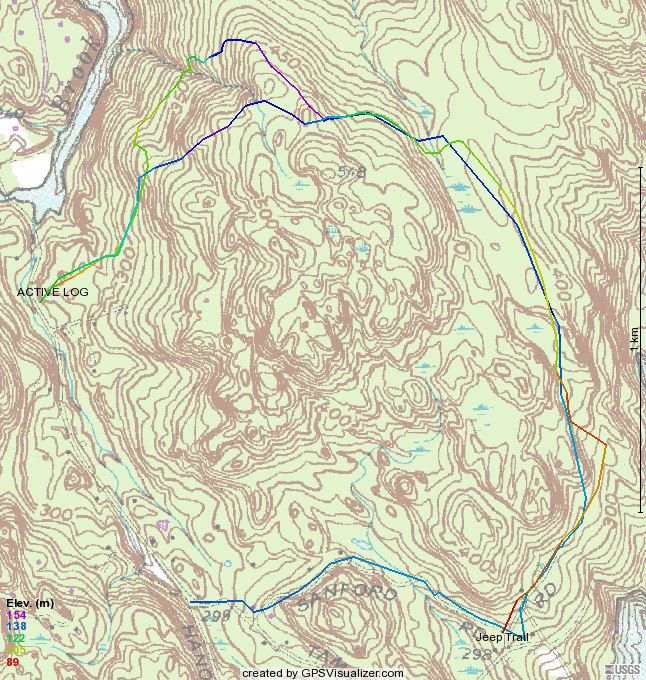
It would make sense that no woodsman or farmer would have climbed directly to the top of the highest point in the forest like the Forest Road (aka Pauly Brody Road) does, so on my ride yesterday, I hung a right into the clearing that I always pass while riding up the backside of said hill. Lo and behold I found a road that skirts the top of the hill. In fact it was cut out of the side of the hill in some spots. While I wasn't paying too much attention but I think there might even be a connector to the blue trail that connects to the white trail that goes to kissing oak. So, here is my ride pull an earlier track of just the Forest Road.
This finally closes the gap of this blue tape trail that I started following last summer north from the forest road but lost it 100 yards in. I am still working on a comprehensive map of all the trails in the Upper Paugussett that once complete I will publish on Bikerag. Since there are hiking trails in the forest, I will point those out in the map, too. According to my friends at NBLA, the Bridal Path (aka West Side Bridal Path in some earlier posts) that would lie atop some blue blazed trail is taking a somewhat circumventing route. Apparently NBLA and The CT Horse Council is taking the top down approach with CFPA in trying to get their trail started. So, I am still waiting to hear back from them. I am planning to walk (uggghh! I hate walking) the trails with my NBLA contact come spring. It could be fun, I can try out the kid carrier backpack that my wife gave me for my birthday, last week.
I found out that AMC is planning a hike in the Upper Paugussett SF next week, Thursday. A friend of mine's husband from Open Space told me that it was said at one of the local health clubs that an individual broke his collar bone in the Upper Paugussett. Anyone reading this from Newtown who might have more details on this, please contact me.
No comments:
Post a Comment